Geomatics News

We have provided this Geomatics News section to allow our members and corporate sponsors the ability to share any geomatics related news or information with the geospatial community.  This page works much like a typical blog, so others can add comments to any news post, or include the information on their own website using the RSS feed

To expand the content, simply click on the article title, click the blue arrow located after the title or click the Read more link.

To add geomatics related content simply click the 'add post' button below and enter your details in the appropriate boxes that appear. [Note: you must be logged-in to your GANS member account to post information below, so if you do not see a button then you may not be logged-in].


  • 12 Jun 2020 5:41 PM | Deleted user


    Connect with Erica on LinkedIn here

    In this Q&A, Erica Corbett of Esri Canada discusses where her interest in geomatics stems from, how it got her to where she is today, and the challenges and rewards that she experienced along her way:


    Q: Can you tell us a bit about yourself?

    A: My name is Erica Corbett and I’m an instructor at Esri Canada. My career path in GIS all started back in my days at uni, in one of my favourite places on this earth: Newfoundland. I took Geography as a Science at Memorial University (MUN). In between having fun on George Street, I was lucky to take various field courses that allowed me to travel around the province and study the beautiful physical and cultural geography of Newfoundland. Rocky coastlines, fjords, glaciers, and mountains in the west, and rolling hills, icebergs, Irish pubs and whale-spotting in the East. I even got to walk along the Earth’s mantle while hiking the Tablelands in Gros Morne National Park.

    It was in one of these Physical Geography classes that I was introduced to the world of GIS. To be honest, I didn’t really like it at first. But once I learned what the software (ArcMap at the time) could do with the data I collected out in the field, I was intrigued.

    Fast-forward to graduating from MUN, I moved to South Korea to give teaching a go. I taught English and traveled Asia for almost 4 years, and while I was enjoying this career path, I knew I wanted to use my degree and get back into my field. I also knew I loved to teach. So I thought, why don’t I combine the two? While sitting in my little studio apartment in Seoul (metro population: 50 mil), I signed up for the Centre of Geographic Sciences (COGS) in Lawrencetown, Nova Scotia (population: 600). It was perfect, as it’s just a 2 hour drive from where I grew up, in Halifax, Nova Scotia.

    The following summer of 2017, I packed my bags and came back to Canada. I did not realize what was in store for me as I walked in the door at COGS on my first day, where I learned I was enrolled in nine courses in my first semester. This 9 month program is called the Advanced GIS diploma program, and you need a degree in order to register for it. I made lifelong friends, became well-acquainted with the Royal Canadian Legion and the game of Broomball, and learned an incredible amount about GIS in those nine months. The courses were extremely technical and prepared me for the job I have today at Esri Canada.

    Before graduating from COGS, I got a job offer for an Associate GIS Analyst position in Esri Canada’s Vancouver office. During my interview, I was asked what my career goals were and I replied that I wanted to be able to combine my passions for teaching and GIS. I started in July 2018, learned a ton as an Associate, and became an ArcGIS Instructor in November 2019.


    Q: What made you choose a career in the geomatics sector?

    A: Being able to combine my interest for Science with Geography led me to working in Geomatics. I also learned how much GIS is applied as an aid to many different spatial issues around the world, making it a very rewarding sector to be involved in. I enjoy working with the many different people in Canada who are users of Esri software and helping clients apply different solutions to their workflows with Esri technology.


    Q: As a woman, did you recognize the barriers you faced in getting your career started? How would you describe them?

    To be honest, while getting prepared for a career in geomatics at COGS, more than half of my classmates were women. As well, Esri Canada hires roughly 3-5 Associates every year, right out of school. In my year, they hired four women (including myself) and one male. So my experience of getting my career going in the Geomatics sector was actually that it seemed like a female-dominated industry.


    Q: How did you manage to overcome the major challenges in your career and end up where you are today?

    The major challenges in my career mainly involve keeping up with the constant change in technology. The only way to do this is to continuously keep learning. I am constantly in communication with my colleagues and am always finding out about new software that Esri is developing that I need to know the ins and outs of. Not only do I learn from my coworkers, but also from my clients, many of whom are long-time GIS users. I enjoy building good relationships with customers all around Canada and taking the opportunity to teach each other something.


    Q: Do you think the geomatics sector needs to change to be more inclusive? How?

    Although I started off my career in Geomatics surrounded by bad-ass women, as I get deeper in my career, and get to know more and more clients, I realized that this sector wasn’t always so female-dominant. In fact, it was the opposite. I’m now on a team of mostly men and a lot of the clients I work with are males as well. It wasn’t hard to notice that there is little to no female representation in higher positions within the GIS industry after working with so many different organizations. With that being said, I think that my experience alone shows that it’s changing.


    Q: What advice would you give to women and girls who are facing gender barriers in their careers?

    A: Be humble. Never stop learning. Ask questions. Speak your mind. Most importantly, be yourself.


    Q: What advice would you give to anyone facing challenges in their geospatial occupation, or entering the geospatial sector?

    A: If you are just entering the geospatial sector: recognize that you have barely scratched the surface of what you can do with the technology (like me). Even if you aren’t new, there are so many people in the GIS industry that you can learn from. Take every opportunity you get to soak in knowledge. And read. Read documentation, blogs, articles and books. Play around in the software until you understand how something works.

    As for anyone facing non-technical challenges regarding their careers: be vocal. Make it clear to your managers (and yourself) what your goals are and how you plan on getting there.


    Q: In your experience, what can you say about the progress that has been made in the geomatics sector, and where it will go in the future?

    A: Judging from my own experience at COGS, and my recent visit to COGS to recruit new Associates, more women than men will be joining the industry. I have no doubt that many of these talented females will make it far, into upper-management roles. I spoke to quite a few women at COGS while conducting interviews who expressed interest in leadership positions. This comes as no surprise to me. While I’m still new to the industry, I’m excited to see where all these new faces will take us, whether male or female. It’s all about ideas and a willingness to learn.


  • 16 May 2020 3:11 PM | Deleted user


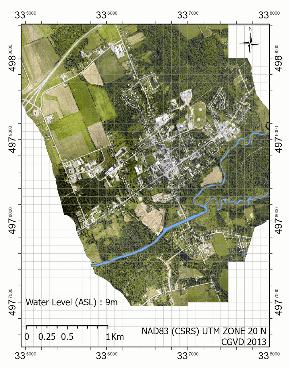
    Image Title: Remote sensing application for flood risk mapping: merging LiDAR technology, digital elevation models (DEMs), and hydrologic conditioning for the city of Middleton, Nova Scotia

    Image Caption: This flood map animation was created using a 1m bare earth DEM derived from a LiDAR point cloud. The data was originally acquired through an aerial survey by the Applied Geomatics Research Group using a topo-bathymetric sensor. As students, our task was to apply hydro-conditioning to the original DEM using ArcGIS PRO and ModelBuilder. In part, this involved creating an automated workflow that would be filling sinks (gaps in the DEM), apply a breach to digital dams (for instance bridges that block the flow of water across the DEM), and enforce hydrologic connectivity between water bodies (culverts). This process resulted in a surface that would mimic the natural flow of water across the watershed (hydro-enforced). Finally, a series of hypothetical flood iterations were generated with levels ranging from 9m to 16m (ASL) using increments of 0.5m.


    The GANS “Student Highlight” article series recognizes budding geomatics professionals and allows them the opportunity to showcase their work, their skills and their career aspirations to the greater geospatial community of Nova Scotia and Atlantic Canada. In each quarterly newsletter, we will share the journey of one of our student members, how they became interested in geomatics, and what their professional goals are for the future.

    This quarter’s feature is Rafael Del Bello, a postgraduate student of the Advanced Diploma in Geographic Information Systems and Remote Sensing at COGS.

    Connect with Rafael on LinkedIn by clicking here.


    My education & background:

    At the time of this writing, I’m enrolled in the Advanced Diploma in Geographic Information Systems and Remote Sensing at the Centre of Geographic Sciences (COGS). The faculty is located in the heart of the Annapolis Valley in the Village of Lawrencetown, a great rural escape for a city slicker like myself, originally from Montreal.

    The diploma can be described as a comprehensive hands-on geomatics program focusing on current industry-standard applications of GIS, remote sensing and geospatial data analytics. What I find most neat about the diploma is how it touches on both the foundational skills – think scripting with Python, SQL querying, database management, report writing, project management, and spatial statistical methods – and of course on skillsets that are geomatics-specific – think GPS data collection and processing, accuracy assessment, quality control, data integration, geoprocessing, and cartographic presentation techniques.

    For students that choose the remote sensing path like myself, the coursework is heavily focused on satellite sensors and the end-to-end workflow involved with image acquisition, processing, and interpretation. The type of sensors we are exposed to is quite impressive too! It also includes a range of resolutions and types such as multispectral, hyperspectral, InSar and thermal. Finally, we also touch on two of the most promising technology out there, namely UAVs -- also called remotely piloted aircraft systems, or drones -- and Light Detection and Ranging (or Lidar), which is a surveying method that measures distances using laser pulses. For these topics, we have the chance to touch on flight planning techniques, sensor calibration, quality control and assessments, point classification and feature extraction, just to name a few. 

    In the end, what you end up with are both industry-specific and transferable skills useful for wherever you end up. Skills that tallow to solve geospatial problems and communicate the problem to key shareholders whether its a client or your boss. A normal school-year will be topped off with a Capstone project which allows the student to dwell deeper into  a particular subject. In my case, I was able to work on a project involving a best-practice manual for UAV based photogrammetric acquisition and post-processing techniques, in collaboration with the Applied Geomatics Research Group in Middleton.


    What interests me about geomatics:

    My biggest revelation coming to COGS is how the knowledge of basic programming is important and how useful it is to have as a skill-set. I first started with minimal knowledge of programming and scripts, except for the odd command line operation when you're trying to troubleshoot operating systems issues. Now, after hours of practice and late nights,  I enjoy them and try to use them whenever applicable. A script is simply a list of commands that you write executed by a certain program. Ultimately, it allows to transform monotonous tasks into intelligently sequenced steps, and can be quite useful to make work processes autonomous and more efficient. 

    In remote sensing and Geomatics in general, you will end up working with a lot of data. This information, whether they are coordinates (XYZ), images(pixels), vectors(shapes), or point clouds, often requires pre-processing before being integrated into other systems. Knowing how to automate these steps will save you a lot of time, and make your boss very happy. 

    As a bonus, you get a satisfactory feeling when a script you wrote can process hundreds of features seamlessly and exactly the way you programmed it too.


    How I decided on a career in geomatics:

    Earlier in my educational background, I took a bachelor of science in environmental geography due to general interest in earth-science, but it was my interest in UAV mapping that first got me thinking about going back to school. It was in 2018 when I purchased my first UAV and became compliant with Transport Canada and obtained a Canada wide waver for UAV operations. I then started looking at ways to apply this technology professionally, but soon realized that a drone was simply a tool. What I needed was a more solid scientific and technical foundation that would allow me to produce actionable deliverable for decision making, while also mastering the theory behind what I was providing. After attending a few seminars and career events to get an understanding of the industry trend (thank you GoGeomatics)my mind was set. 


    My career goals:

    Like most students graduating in 2020, my main short term goal will be to break into the geospatial industry and build on my current skillsets. I will be pursuing openings as a remote sensing specialist, GIS analyst, data processing specialist, or UAV technician. I’m someone who enjoys multi-tasking and teamwork, therefore my efforts will be targeted to small and medium-sized companies. In the long-run, I hope to find my niche, equip my toolset with additional skills, and be able to manage my team as a geospatial expert.


    My ideal employer:

    I want all the good stuff: a place of work that allows for continuing professional growth, a work environment where there is the freedom to explore new workflows and bring news ideas to the table, and most importantly, a company with strong leadership that stays sharp, observes technological trends and methods, and ultimately, stays ahead of the game.


    Advice for other students:

    The geomatics field is large and encompasses a variety of different fields. Try to connect with professionals from the industry and ask them about what they do. If given the chance, gain some experiences through work terms or volunteering opportunities. All these things will help you find what makes you tick, and most importantly, what doesn'tIn the long-run, this can save you a lot of time and help you focus your efforts in the right direction.


    How students can benefit from associations like GANS:

    As cliche as it sounds, it's not always about what you know but who you know. By planning meetups, conferences or web-hosted seminars, industry organizations are usually entities capable to connect industry experts, business executives, and aspiring workers and students. As far as you know, your next employer could be the person you start chatting up to at an organized event, or it could be a connection to that person! You truly never know. Finally, organizations are also very useful in keeping up to date with technological trends, being informed about the progress in the industry, or simply to know which companies that are making the biggest impact.


  • 29 Apr 2020 11:40 AM | Deleted user

    Events Update

    As you all know, COVID-19 has resulted in set backs for many organizations across the globe, and we are no different. Unfortunately, we have not been able to host you at any in-person events, and will not be able to do so for an indefinite period of time. 

    However, our Events team has been working very hard to plan alternative events and activities to keep you connected and informed on GANS engagements, even from home. Keep reading to hear some of our ideas and what you can expect to see through our channels in the upcoming months!

    Thank you for staying in touch with us and up to date on the geomatics community. As always, your feedback is welcome and you can always reach out to us if you need anything by emailing [email protected]

    Check our Events Page regularly for updates!


    WEEKLY PHOTO CONTEST!

    GANS is going to host weekly photo contests through our Facebook Page, and everyone is welcome to participate. Go to the Page for more info!

    Every Friday, we will post a new theme for the next week's photo contest. Those who follow the rules listed in the image above will have their name entered in a draw to win! Every following Friday, we will announce the winners of that week by sharing their post, and we will also announce the new theme for the next week at the same time. 

    The prize? FREE GANS swag! 


    2020 GANS AGM - TBA

    Due to COVID-19, we as an association are required to defer our AGM until the provincial state of emergency has ended. Therefore, we will not announce the new date until these measures have been lifted, to abide by provincial orders of Nova Scotia and to ensure the safety and wellbeing of citizens. 

    However, in the meantime, we are still seeking new Board Director nominations, and nominations for the GANS Award of Distinction! Keep reading below for more information on these opportunities.

    Any further changes will be announced as they come. 
     

    Click Here for More AGM Details

    Board Nominations:

    We are accepting nominations for board positions, and the new board for 2020-21 will be decided at the AGM event.

    Email your nominations to [email protected]!

    Get "on board" with the new GANS - here's what we're all about:
     

    GANS Award Nominations:

    This special recognition is awarded to an individual or an organization for making a significant mark in the geomatics sector. Every year, one recipient will be presented with the honour during our Annual General Meeting (AGM) which takes place each spring. Nominations for the Award are now open, and will remain open until further notice. 

    Click below for more information on the Award, including the Nomination Form:
     
    GANS Award of Distinction


    Become a GANS Sponsor

    When you become a GANS Sponsor you are not only benefiting your own organization, but you are also helping the Nova Scotia geospatial community. Go to our Sponsors page to learn more about how you can become a sponsor and what your benefits as a sponsor will be!

    Here's an outline of our Sponsorship Program:

    View the full Program HERE


    Article Feature:

    Women in Geomatics Spotlight: Emma Tompkins


    Emma is currently a Remote Sensing and GIS Specialist at Resson Aerospace. Her main role involves working with satellite imagery, which ties directly into what she attended school for. 

    “I originally took a biology degree at St.FX university focusing on ecology, when I got a co-op job working in the Cape Breton Highlands National Park tracking coyotes. These coyotes had GPS collars on them that we used to look at their movements and patterns. My boss told me to look into GIS if I found it interesting and that there was a school in Nova Scotia that specialized in it. So after I graduated X I took the Advanced Geographic Sciences program at COGS and ended up in the remote sensing specialty. The day I graduated COGS I got a job offer from Resson as a Data Processor and I was eventually able to use my GIS and remote sensing skills to help out with more projects we were working on. That eventually led to me being the "satellite person" at work as we were starting to become more interested in imagery over larger areas and I actually had a background perfect for that.”

    Learn more about Emma here
     

    Article Feature:

    Student Highlight: Samuel Jean


    GANS’ new “Student Highlight” article series recognizes budding geomatics professionals and allows them the opportunity to showcase their work, their skills and their career aspirations to the greater geospatial community of Nova Scotia and Atlantic Canada. In each quarterly newsletter, we will share the journey of one of our student members, how they became interested in geomatics, and what their professional goals are for the future.

    This quarter’s feature is Samuel Jean, a postgraduate student of the Advanced Diploma in Geographic Sciences, GIS Program at COGS.

    Find out more about Samuel and his journey here


    FREE GANS Student Membership!


    Job Opportunities

    Looking for work? Check out our Jobs Page for the latest in GIS job opportunities in Atlantic Canada. 

    If your organization has any job opportunities you’d like to post, you can do so by posting on the web site if you are a member, or by sending them to: [email protected]


    Geographic Education Posters: 
    Be Our Next Contributor!

    Did you go to high school in Nova Scotia and are now working in the geomatics sector? We want you to be part of our educational posters! 

    Find out more on our Geographic Education and Geospatial Related Careers page.


    As always, thank you to our dedicated sponsors for your continuous generosity and support!


  • 25 Apr 2020 11:26 AM | Deleted user


    In photo (to left): Samuel Jean Photo caption (to right): For this lab about LiDAR hydrological applications, we hydro- conditioned a LiDAR derived DEM and used it to create flood polygons for incremental water levels.


    GANS’ new “Student Highlight” article series recognizes budding geomatics professionals and allows them the opportunity to showcase their work, their skills and their career aspirations to the greater geospatial community of Nova Scotia and Atlantic Canada. In each quarterly newsletter, we will share the journey of one of our student members, how they became interested in geomatics, and what their professional goals are for the future.

    This quarter’s feature is Samuel Jean, a postgraduate student of the Advanced Diploma in Geographic Sciences, GIS Program at COGS.

    Connect with Samuel on LinkedIn by clicking here.


    My education & background:

    I am enrolled in the Advanced Diploma in Geographic Sciences, GIS concentration. The first term of this one-year post-graduate program includes data analytics, GIS, programming, remote sensing, spatial databases and geodesy courses. The second term includes two mandatory courses (information systems and advanced GIS) and electives. I chose LiDAR, raster modelling and locations analysis courses as electives. I am currently completing my courses requirements from home. Today (April 23), I completed an assignment about solar panel site selection using LiDAR data.


    What interests me about geomatics:

    Raster modelling and LiDAR is what interest me the most. I am particularly interested in species distribution and flood modelling.


    How I decided on a career in geomatics:

    I had my first introductory GIS course in 2014 while doing my bachelor’s degree in Sustainable Development and Coastal Zone. At the time, I was already fascinated by the apparent endless possibilities offered by GIS. I then used GIS software and applications whenever possible during my co-op internships and work experiences in the field of biodiversity conservation and climate change adaptation.


    My career goals:

    I will start working at Acadia University on June first as a Conservation and Education assistant. While in this role, I hope to use my newly acquired skills to raise the public awareness about native species and collaborate with various stakeholders to improve our comprehension of the ecosystems that compose the Acadian Forest Region.


    My ideal employer:

    I like to be active and I have a life-long passion for plants so any position that involves some field work in natural environments is definitely a plus. To me the most important qualities an employer can have are to allow its employees to keep learning and progress in their role by getting new responsibilities, let them be creative in their work, and ensure good work-life balance.


    Advice for other students:

    Previous experiences and COGS brought me a lot, but I still have a lot to learn to be at the stage at which I want to be. Do what you like to do and keep learning! While not at school, make the most out of online learning platforms such as Coursera and edX, connect with people that inspire you and get out of your comfort zone.


    How students can benefit from associations like GANS:

    A membership with organizations like GANS is a chance to participate to events and network with various professionals, with whom I might develop partnerships to work collaboratively on projects that could benefit us both.

  • 18 Apr 2020 11:09 AM | Deleted user


    Emma is currently a Remote Sensing and GIS Specialist at Resson Aerospace. Her main role involves working with satellite imagery, which ties directly into what she attended school for. 

    “I originally took a biology degree at St.FX university focusing on ecology, when I got a co-op job working in the Cape Breton Highlands National Park tracking coyotes. These coyotes had GPS collars on them that we used to look at their movements and patterns. My boss told me to look into GIS if I found it interesting and that there was a school in Nova Scotia that specialized in it. So after I graduated X I took the Advanced Geographic Sciences program at COGS and ended up in the remote sensing specialty. The day I graduated COGS I got a job offer from Resson as a Data Processor and I was eventually able to use my GIS and remote sensing skills to help out with more projects we were working on. That eventually led to me being the "satellite person" at work as we were starting to become more interested in imagery over larger areas and I actually had a background perfect for that.”


    In this Q&A, learn more about Emma’s journey in discovering her interest in geomatics, how she got to where she is today, and what she learned along the way:


    Q: In your experience, please describe how far the geomatics industry has come to be diverse and inclusive to all groups, including women. Do you think there is still work to be done?

    A: I'm still relatively new to the work force, I only started working in the field in 2017, but when I went to school we had people from all over the world at COGS and while women didn't make quite up half of the class there definitely was more than I had expected. I think this seems to reflect the trend of the new workforce entering the geomatics industry. There seems to be more diversity in the workforce every year. But there's always room for improvement!


    Q: During your education or the start of your career, did you notice that positions within geomatics are typically male-dominated roles? (i.e. did you notice high ratios of male:female in your classes, workplace, etc.?)

    A: When I started my work at Resson I was surprised to be join a department where two out of three were women. As the company has grown this department has changed roles a bit and we expanded to include an office in India, where our department there also has a majority of women! Myself and the original two have moved on to roles with more responsibilities within the company. In general, my colleagues are mostly male. It's still definitely male dominated in most of the departments and, but there are quite a few women here that bring skills to the company that we would be lost without and it doesn't go unnoticed. 


    Q: What were the most challenging aspects in your career development? How did you overcome those obstacles?

    A: Keeping up with how fast technology is changing, there's always new things to learn that will help further my career. I think I'm still trying to keep up, but I try to stay on top of things with online courses and keeping up to date on what is happening in the remote sensing world, there's always a new satellite going up to learn about.


    Q: At what point in your career did you feel satisfied that you made the right choice entering the geospatial sector? If you could go back, would you change anything?

    A: I think when colleagues started approaching me for advice and help on how to complete a GIS-related task, or for input on a new project was when I started to feel like I was becoming a valuable employee. I started feeling more confident about my knowledge and saw a direct impact I was making which showed to me that I made the right choice in entering this sector. Although I still frequently have impostor syndrome and think I don't know as much as I do, but  the more I continue to learn and further my skills the more it goes away, I need to remember that I was given my responsibilities for a reason! 

    If I could go back I think the only thing I would change is when I was at school I really hated python and didn't try as hard as I should have to understand it. Now I use it everyday, and only just started learning all these open source GIS libraries. I wish I had taken it upon myself to look into open source options sooner!


    Q: What changes would you like to see in the geomatics community to make opportunities more inclusive to people of different backgrounds, particularly women?

    A: I think I would like to see for most workplaces in the geomatics communities is to have more women and people of different backgrounds in upper-management and on the board of directors. Having a diverse group of people making big decisions would help bring more perspectives to the table. 


    Q: To a woman considering entering a career in geomatics, what would you say is the most important consideration as a first step to getting started?

    A: If you are considering a geomatics field there are tons of free courses and tutorials online for beginners so you can try it out and see if it's for you. It can be a little intimidating going into the STEM field where you may be in the minority, but in my experience the majority of people are friendly and willing to collaborate regardless of who you are.


    Q: In general, what advice would you give to women and girls who are facing gender barriers in their careers?

    A: Don't be afraid to speak up with your ideas, you may have some that no one has even considered. 


  • 05 Feb 2020 8:14 PM | Deleted user

    Dear GANS Community,

    We are excited to share some updates and upcoming geospatial events! Read the GANS Winter 2020 Newsletter for recaps on recent engagements and to get the scoop on new opportunities to look forward to!

    All the best,

    GANS Board of Directors


    Event Recap

    Thank you to everyone who participated in our recent events! We hope you enjoy them. As always, feedback is welcome and we look forward to hosting even more and even better activities for you!


    Professional Development Day:
    Smart Cities & Communities - November 26, 2019

    In November, we hosted a Professional Development Day Series Event, 'Smart Cities & Communities: A Spatial Approach to Efficiency." 

    Organizations that presented:

    • Halifax Water
    • CarShare Atlantic
    • iValley
    • ESRI
    • Black Arcs 
    • Green Power Labs
    • DalTRAC
    • City of Summerside


    GANS & GoGeomatics Holiday Social - November 26, 2019

    After the Smart Cities event, we enjoyed a night cap with community members and celebrated the holiday season!


    COGS Industry Expo - January 21, 2020


    GANS recently had a table at the COGS annual Industry Expo event to share with students and professionals what we do, how to pursue a career in geomatics, and how we together can contribute to the geospatial community. COGS invited students, faculty and professionals all to attend, and we enjoyed taking part. Thank you all who came and said say "hi!"

    GoGeomatics Social - January 22, 2020


    As part of the COGS Industry Expo, there was a GoGeomatics Social held at Lunn's Mills Beer Company on January 22nd. GANS sponsored the event with finger food and info. Thanks to all who turned out, and to the 40+ students!


    Upcoming Geomatics-Related Events in 2020

    Check our Events page regularly to stay up-to-date on all future GANS events!


    Professional Development Day:
    Digital Twins Technology and Building Information Modelling (BIM) - February 25

    Register Now

    2020 GANS Annual General Meeting - May (TBA)


    Become a GANS Sponsor

    Go to our Sponsors page to learn more about how you can become a sponsor and what your benefits as a sponsor will be!

    Here's an outline of our Sponsorship Program:


    Article Feature:

    Women in Geomatics Spotlight: Lucie Kendell

    Read about Lucie here


    FREE GANS Student Membership!

    For more information, go here


    Geographic Education Posters: 
    Be Our Next Contributor!

    Did you go to high school in Nova Scotia and are now working in the geomatics sector? We want you to be part of our educational posters! 

    Find out more on our Geographic Education and Geospatial Related Careers page.


    GANS Membership Renewal - Reminder

    A note from Dave, GANS Treasurer: "Just a friendly reminder - don't forget to renew your GANS membership if you haven't already! Check your early January emails as you may have received a renewal notice from us. And thanks to you who've already renewed!"

  • 25 Jan 2020 9:45 AM | Deleted user

      .      


    "My name is Lucie Kendell. Originally from Bridgetown NS, I now live in Beaver Bank NS. I love traveling, cheering on my kids at the rink or on the field, trying new foods or craft beers, and relaxing at the cottage with family and friends.

    I am currently employed at Halifax Water as the coordinator of the GIS Business Solutions group. We are one of three teams within the Engineering Information group. We strive to deliver map and app solutions in support of Utility operations, as well as delivering on service requests for Utility GIS data.

    I have a degree from Mount Allison University; major in Geography with a minor in Canadian Studies. I also have an advanced diploma from the Centre of Geographic Sciences (COGS) in Marine Geomatics.

    My career started in 2002 at a small geophysical surveying company in Porters Lake – Canadian Seabed Research. We worked hard and I got my hands into all aspects of the business – mobilization, surveying/data collection, data processing, interpretation, and report preparation. I learned a lot in three years with that company and travelled to some interesting places (i.e. Eastern Russia and the Beaufort Sea). In 2005 I took a GIS technician job with Jacques Whitford (now Stantec). I was able to specialize and further develop my GIS and mapping skills, and I got to stay closer to home! In 2009, I jumped when the opportunity arose to work for Halifax Water, where I’ve worked as an Engineering Information Technician, a GIS Analyst, and now as a coordinator."


    In this Q&A, Lucie discusses where her interest in geomatics stems from, how it got her to where she is today, and the challenges and rewards that she experienced along her way:


    Q: What made you choose a career in the geomatics sector?

    A: Geography – literally. I grew up down the road from COGS and had heard of the opportunities available to its graduates. When I graduated from MTA, I was considering education. However, looking through the COGS syllabus, the marine geomatics program caught my eye. I thought “seismic” had something to do with earthquakes, which I thought was pretty interesting. It wasn’t until my first week in the program that I understood what I’d really gotten myself into, but I’ve never looked back or reconsidered anything besides a career in geomatics!


    Q: As a woman, did you recognize the barriers you faced in getting your career started? How would you describe them?

    A:  I don’t think I was, no. I had a lot to learn, working my way around the ships I suddenly found myself on. There were very few women (if any!) on the boats or involved in our projects. I was often given “special” accommodation (i.e. single berths/facilities, once I even received a weekly chocolate bar ration, lol) and mostly everyone I’ve worked with has been very respectful and taught me a lot.


    Q: How did you manage to overcome the major challenges in your career and end up where you are today?

    A: A notable challenge I’ve faced throughout my career has been staying positive when “times get tough”. For example, working offshore in remote areas of the world was a wonderful opportunity… when I was young and carefree with minimal at-home responsibilities! As I started to wish for things like pets, family, and the freedom to make extracurricular commitments, the opportunity turned into a burden. When anything in my career has become less than positive, I’ve tried to take the time to evaluate potential solutions. What can I do to directly improve my satisfaction at work? A new project? A new job? An extended holiday? A new volunteer opportunity? It seems like a simple thing, but I’ve always tried to stay accountable for my own contentment – then there is no one else to blame!


    Q: Do you think the geomatics sector needs to change to be more inclusive? How?

    A: I believe we should always strive to be more inclusive, in any sector. Further education in the field of geomatics, professional development opportunities, and career prospects may help to engage a wider audience. I’ve participated in the NSCC’s Techsploration program, which is doing a fantastic job of introducing young women to a cross-section of STEM fields, including geomatics. It’s encouraging when professionals participate and support their sector through programs like this. The introduction of financial support programs, scholarships, internships, and co-op programs may also help break down barriers and provide opportunity.


    Q: What advice would you give to women and girls who are facing gender barriers in their careers?

    A: Be confident in your skills/abilities and learn how to successfully communicate your value to a potential employer. Know yourself, strengths and weaknesses, and search for a healthy fit. If you find yourself constantly facing barriers or unhealthy career challenges, evaluate possible solutions. Are you able to improve your situation? If so, do it!


    I recognize that I’ve been quite fortunate in my career, and I appreciate my situation today. I often find myself around a table tackling project requirements or brainstorming solutions with many amazingly talented women, all of whom have inspiring stories. We’ve made it beyond those barriers, and you can too.


    Q: What advice would you give to anyone facing challenges in their geospatial occupation, or entering the geospatial sector?

    A: I find it increasingly tough to “stay relevant” in our technical field. I would encourage anyone to take advantage of professional development opportunities (training, conferences, networking events, etc.). Part of this involves expressing interest, providing feedback, lobbying for change, and engaging with management who are making those decisions that directly impact your situation.


    Speak your mind; communicate in a constructive way and be creative! The opportunities for growth may not even exist yet when it comes to established job descriptions/positions.


    Q: In your experience, what can you say about the progress that has been made in the geomatics sector, and where it will go in the future?

    A: It blows my mind! I’ve been in the field now for 20 years and I can’t believe what we’re doing today with the technology compared to project work I was doing at school with ‘cutting edge’ software in 1999. From a Halifax Water perspective, thanks to configurable Web GIS applications and a GIS-based work order management system, almost every employee is a daily GIS user! The progress is exponential – reinforcing my previous comments on the need to stay relevant with constant professional development. My guess is that the future will bring enhanced on-the-fly analytics, greater accessibility by all, 3D, and VR… but who knows?

  • 09 Dec 2019 5:22 PM | Deleted user

    Maggie is a GIS Analyst with the Municipality of the County of Cumberland and has been since 2008. She underwent the Cartography program at the NSCC Centre of Geographic Sciences (COGS) to accomplish her profession. Originally from Dartmouth, NS, she has been located in the Sackville, NB, area for the last 12 years. Previous employers include: the Nova Scotia Geomatics Centre, SNC-Lavalin, MapDrawer Cartography, and COGS.

    The below Q&A will explore the obstacles that Maggie overcame, and the achievements that resulted, ultimately leading to where she is today:


    Q: What made you choose a career in the geomatics sector?

    A: I was looking for a career with good prospects that was fairly quick to achieve at a low cost. Returning to school as the lone-parent of my two-year-old son in 1999, practicality was forefront in my mind. That said, it also had to be interesting. The COGS Cartography program fit the bill and struck me as requiring a mix of creative and technical thinking, which really appealed to me. It didn’t hurt that I had previously enjoyed a drafting class and grew up poring over National Geographics.


    Q: As a woman, did you recognize the barriers you faced in getting your career started? How would you describe them?

    A: I started my career pretty quickly and easily, and have always felt quite lucky in finding great opportunities in the Geomatics sector. There were certainly hurdles, but nothing insurmountable.


    Q: How did you manage to overcome the major challenges in your career and end up where you are today?

    A: Being adaptable has probably helped me more than anything when things have been especially challenging or have taken an unexpected turn. Perseverance, an appetite to learn, and creating my own opportunities at times has carried me through.


    Q: Do you think the geomatics sector needs to change to be more inclusive? How?

    A: Certainly, the geomatics sector could be more diverse and welcoming. Raising the profile of geomatics as a career for all in earlier school years might help to capture a broader base. Also, we can all work to improve work environments and inclusivity as a whole, in any workplace. Recognizing and removing obstacles that might inhibit some from entering or flourishing any sector is important for the diversity of that industry. Leaving assumptions and bias at the door is a practice we should all develop.


    Q: What advice would you give to women and girls who are facing gender barriers in their careers?

    A: Dr. Mae Jemison said it best. “Never be limited by other people’s limited imagination.”


    Q: What advice would you give to anyone facing challenges in their geospatial occupation, or entering the geospatial sector?

    A: Find the geospatial niche that excites you most and run with it.


    Q: In your experience, what can you say about the progress that has been made in the geomatics sector, and where it will go in the future?

    A: It has been exciting to be part of such a quickly evolving technology! I see it becoming a bigger part of the technological tools used by non-GIS people to make better decisions.


  • 26 Oct 2019 11:30 AM | Deleted user

    Contributed by Alexandra Baird Allen of Turner Drake & Partners Ltd.

    "Turner Drake was founded in 1976 to provide real estate services to the business community in Atlantic Canada.  In 1998 we expanded our service area to include Ontario, to meet the demands of clients owning property there as well; we have also undertaken assignments from coast to coast.  Through our various affiliations we can offer valuation services throughout the United States and the United Kingdom. Our team approach ensures that we are uniquely equipped to provide professional assistance in the fields of valuation and appraisal; property tax; counselling (expropriation, feasibility studies, portfolio and asset analysis); Lasercad® space measurement; economic intelligence (market surveys, site selection, trade area analysis, supply and demand analysis); planning; and brokerage (sales and leasing).  Turner Drake & Partners Ltd. is a professional services firm regulated by the Royal Institution of Chartered Surveyors, and All operations of Turner Drake & Partners Ltd. are covered by a quality system registered to the ISO 9001:2015 standard.

    "We provide solutions to real estate problems": that is our mission, and to fulfil it we develop long term relationships with our clients, in effect becoming their real estate arm.

    Real estate is a multi-faceted challenge and rarely receives the attention it deserves; despite the fact that it is usually the most valuable of fiscal assets. Nor are the diverse skills necessary to protect and nurture the real estate investment readily available to the average property owner.  They must instead be sought from a variety of ad hoc sources: appraisers, sales and leasing agents, tax consultants or other professional advisors such as lawyers or accountants.  As a result the advice is often contradictory or too narrowly focused: as a consequence it may be of doubtful validity.  We have addressed this problem by training our own team of real estate specialists.  They have outstanding experience and qualifications.  We have carefully assembled exceptional resources, databases, computer facilities and superb contacts, to ensure that our team has a thorough knowledge of the Atlantic Canada and Ontario real estate markets at all times.  In 2006, Turner Drake brought in GIS as a tool to view and analyse data spatially…quite sensibly, given that real estate is all about “location, location, location.”   

    GIS plays a key role in what we do.  One such recent project was a land suitability analysis which we undertook for a municipality in Atlantic Canada. They wanted to identify which of four potential sites would give them the best “bang for buck” for a comprehensive new community development.  In order to provide an unbiased, fact-based opinion of which site would be the best candidate, we overlaid a variety of geographic data: property boundaries and ownership; locations of municipal services – from transit and active transportation networks to water and sewer services; topographic data pertinent to each of municipal servicing and environmental features and sensitivities; and demographic information.  Using a weighted ranking system, we were able to codify the complex pros and cons of each site into a succinct ranking of the four sites.  Our Economic Intelligence team conducted the geographic analysis; our Planning team weighed in on the municipal planning considerations of each potential site; and our Valuation team provided a preliminary estimate of acquisition costs for each site, followed by a more comprehensive valuation of the two short listed sites.  At all times during the process, we maintained open lines of communication with our client, keeping them informed of issues and opportunities as they arose, and tweaking the analysis as needed to ensure it provided the most accurate, reliable, and transparent solution to their real estate problem."

    In photo: "Just a few of the datasets we used to help our client solve their real estate problem; reconciling a complex set of inputs into a succinct recommendation is our specialty." - Alexandra Baird Allen


  • 26 Oct 2019 11:08 AM | Deleted user


    Dear GANS Members,

    Since our last newsletter, GANS has undergone a few changes, including administrative and functional (involving recent and upcoming events). We are excited to share these updates with you, as well as recap some past events, and announce upcoming engagements!

    Enjoy!


    Administrative Updates

    In terms of role changes, GANS' Communications Coordinator - Harrison Ellis - recently moved on and a new Coordinator, Laura Olsen, joined the team in September.


    Laura Olsen is from the Annapolis Valley, and moved to Halifax to complete an undergraduate business degree at Saint Mary's University. Now graduated, she has an interest in online business management and is currently pursuing work as a Virtual Assistant. Laura enjoys travelling, trying new things, and outdoor adventures!


    A note from the GANS Treasurer:

    Since our inception in 1986, GANS has changed with the times and adopted new methods to manage our financial obligations; many of you use our online WildApricot & AffiniPay systems to register for membership and events; our newsletters use a MailChimp e-mail system. In the past year, we realized that the old bank account we had just couldn’t afford us the full capabilities of modern, online banking. As of June 2019, we've modernized our banking!

    So, over the past six months, we’ve been switching to a new account with the Royal Bank of Canada that allows e-transfers, reduces costs, and better manages our accounts and to QuickBooks (online). It’s taken longer than expected, though; as volunteers, it can take some time to get signatures and improve workflows, etc. The switch is almost done, and that'll allow us to spend efforts on day-to-day aspects of our financials. We have a small working group comprised of Murrium and Jon (Board Reps), Bridget (Financial Co-ordinator), and myself (Treasurer) guiding our energies & time. And, if you’re wondering, we are in good financial health. Thanks for your support!

    Regards, 
    Dave MacLean

    Event Recap

    Thank you to everyone who participated in the Georges Island tour with Parks Canada in August! The tour sold out quickly, and we will keep everyone posted on the next one that is organized. Check out the video that Smarter Spaces captured from the tour!

    We also recently attended the GoGeomatics Back-to-School Social at the NSCC Centre of Geographic Sciences in Lawrencetown, NS on October 4th. Thank you for everyone who took part in the networking, wonderful discussions and snack-sharing!


    Upcoming Events

    Check our Events page regularly to stay up-to-date on all future GANS events!


    Smart Cities & Communities: A Spatial Approach to Efficiency

    Register Now

    GANS is hosting an all-day professional development seminar titled, Smart Cities & Communities: A Spatial Approach to Efficiency!

    When: Tuesday, November 26, 2019 from 9:30am to 4:00pm
    Where: Halifax Central Library, Spring Garden Road, Halifax (Room 301)
     
    In this seminar, professionals will share their experiences with solving work dilemmas through a spatial approach. You will have the opportunity to discuss how organizations in different areas, private or public, for-profit or non-profit, are using smart technologies to improve efficiency from a geospatial perspective. You will learn how cities and communities in the Maritimes are currently adopting and planning to adopt smart technologies via the Internet of Things (IoT) and spatial systems such as GPS receivers and GIS networks. By the end of the day, you will know more about the impact that spatial systems have on the efficiency of your community!

    Note: in an attempt to keep the registration fee as low as possible, lunch will not be provided (though there are many terrific pubs and eateries within easy walking distance of the library!).  
     
    Feel free to contact us by email at [email protected] 

    P.S. We are still in need of speakers for the event, so please let us know if you are interested and spread the word to your colleagues and friends!


    GIS Day 2019

    As a way of celebrating this special day of recognition, GANS Treasurer - Dave MacLean - has registered an event at the NSCC Centre of Geographic Sciences in Lawrencetown on November 13th.

    This event will showcase various geospatial technologies and their capabilities, stimulate discussions on the current developments in the geomatics sector, and spread awareness about GIS day to the public. 

    There will also be cake! For more information on GIS day, go here

    Stay tuned in on our website and social media for more updates!


    Sponsor Spotlight: Turner Drake & Partners Ltd.

    Contributed by Alexandra Baird Allen of Turner Drake & Partners Ltd.

    "Turner Drake was founded in 1976 to provide real estate services to the business community in Atlantic Canada.  In 1998 we expanded our service area to include Ontario, to meet the demands of clients owning property there as well; we have also undertaken assignments from coast to coast.  Through our various affiliations we can offer valuation services throughout the United States and the United Kingdom. Our team approach ensures that we are uniquely equipped to provide professional assistance in the fields of valuation and appraisal; property tax; counselling (expropriation, feasibility studies, portfolio and asset analysis); Lasercad® space measurement; economic intelligence (market surveys, site selection, trade area analysis, supply and demand analysis); planning; and brokerage (sales and leasing)." 

    Read more here.


    Become a Sponsor

    When you become a Geomatics Atlantic Sponsor you are not only benefiting your own organization, but you are also helping the Nova Scotia geospatial community. Go to our Sponsors page to learn more about how you can become a sponsor and what your benefits as a sponsor will be!


    Women in Geomatics Spotlight: Sarah Dunnewold

    Sarah works for the Province of Nova Scotia at the Geomatics Centre as a GIS Administrator. 

    "I worked at numerous places where I was able to use GIS for different purposes which expanded my knowledge and thought processes.   I like to create, so in my personal time I mix cartography with craft and I make rugs using of special places using open-source software and open data."

    Read about Sarah here.


    Geographic Education Posters: 
    Be Our Next Contributor!

    Did you go to high school in Nova Scotia and are now working in the geomatics sector? We want you to be part of our educational posters! 

    The GANS Geographic Education Posters are created to help young people identify some of the endless possibilities that learning geography provides, by highlighting the various different geography related post-secondary education programs and geospatial related career opportunities available. All the geomatics related professionals featured here are graduates from various Nova Scotia high schools and have followed a variety of post-secondary paths, including both colleges and universities, to get where they are today. Geography Matters! 

    The custom designed posters are professionally printed and sent to the corresponding high school that the featured professional graduated from. We believe that this initiative helps promote both high school geography and our industry, ultimately resulting in more students pursuing geospatial studies and careers after they leave high school. It also provides more knowledge to the teachers, parents, and the general public about what our industry does, and how we provide services and knowledge that they depend upon every day. 

    Find out more on our Geographic Education and Geospatial Related Careers page.


    GANS Membership Renewal

    Remember to renew your GANS membership if you haven't already!

    Renew

Check out the Geomatics Association of Nova Scotia Sponsors map


© Geomatics Association of Nova Scotia (GANS) - PO Box 961, Halifax, NS, B3J 2V9

Help us promote Geomatics in Nova Scotia by joining us in the following social media groups:

Follow The Geomatics Association of Nova Scotia (GANS) on Twitter Join The Geomatics Association of Nova Scotia (GANS) on Google+ Join The Geomatics Association of Nova Scotia (GANS) on FaceBook Join the The Geomatics Association of Nova Scotia (GANS) LinkedIn group add GANS news to your website via our RSS feed

Website design and management of Geomatics Association of Nova Scotia courtesy of tmackinnon

Powered by Wild Apricot Membership Software